Commerce and the circulation of capital has been a key
concern of local politicians and planners in the Modern
Era. Technological innovations of the 19th century transformed
the Western world into industrial spheres. The railroad
and steam engine created paths along which industry and
trade centered. Chicago grew at such a trade nuclei. Urban
planning became essential to organize complex infrastructures
including transportation, communications, sewage and electricity.
Technological innovation became synonymous with the notion
of progress and modernization became the ideology of not
only industry but also the goal of urban planning. According
to Graham and Marvin in Splintering Urbanism, Western
societies regarded the standardized, orderly and unitary
city plan as the culmination of the modernist project throughout
the mid-19th century until the mid-20th century (62). During
this period of 'the modern unitary city ideal,' issues of
infrastructural and technological investment dominated urban
politics. Western cities were transformed from unplanned,
fragmented- networked systems into centralized and standardized
systems under the logic of Haussmannnisation (40-42).
These systems were meant to provide both predictable and
dependable services within urban space and in larger trade
networks. Such cities were viewed as organisms with a circulatory
system that transported goods, capital and individuals;
and respiratory systems or green space that maintained civic
and recreational health of the city (55, Burnham 80-87).
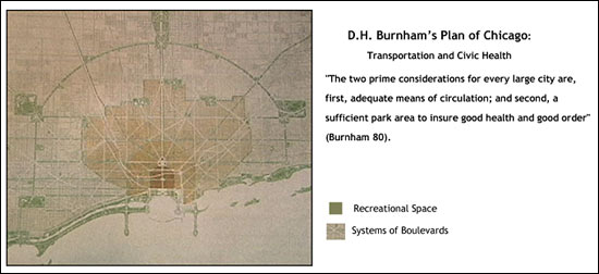
Burnham's plan of Chicago strongly emphasized an articulation
between recreational spaces and spaces that facilitate economic
flows. His plan was largely implemented. Thanks to Burnham's
plan, the entire shoreline along Lake Michigan is public
park space, and today the lake shore path serves as a transportation
highway for bike commuters and a recreational path. Burnham's
plan was largely accepted by the city because his representations
of space fit the city's idea of how Chicago had began and
would continue to develop. Burnham's ideas evolved from
a representational space to a representation of space that
the city used to design its infrastructure. This form influenced
practices of Chicago residents, and although infrastructure
of Chicago was lain in the early 1900s, space continually
is produced and reproduced through social practice and redevelopment.
"It was Haussmann's theory that the money thus spent made
a better city, and that a better city was a greater producer
of wealth" (Burnham 18).
Chicago's transportation networks facilitated a healthy
flow of capital and the city became America's main non-coastal
transportation hub (Miguel D'Escoto (CDOT), City Club of
Chicago meeting Oct. 7, 2002). His plan organized the transportation
networks into a system of radials and circuits (Burnham,
68). You can see how these circular loops spread westward
from the lake in the plan displayed above. These thoroughfares
consisted of both rail lines, a subway system and roads.
These loops were crossed by a system of diagonals designed
to save transportation time and increase circulatory efficiency.
Many diagonals 'fortunately' already existed in Chicago
before Burnham's plan (84). These radials and circuits were
lain upon a gridion system of local roadways. Boulevards
were designed mainly in residential areas so "the working
people will enjoy a maximum of fresh air and light; and
so will work with the greatest effectiveness" (86).
Beautification of the transportation infrastructure was
key to the city's civic and economic health for Burnham.
He proposed many ways to beautify the city-some were built
others remained in the space of plans. Disgusted by the
unsightly prominence railroads had taken in many other modern
cities across the world, he proposed that the freight infrastructure
be built underneath passenger infrastructure. This happened
in part by the construction of sub-ways and the 'El' or
elevated mass transit system. An aesthetic arrangement would
not only beautify the space but also enhance efficiency
of circulation. "Cleanliness and pleasing treatment of the
roadways, the embankments, the drainage channels, the fences,
yards and the stations large and small insure better service
on part of railroad employees, while the appearance of the
city is immensely improved thereby" (Burnham, 70).
Boulevards were designed mainly in residential areas so
"the working people will enjoy a maximum of fresh air and
light; and so will work with the greatest effectiveness"
(86). Burnham's intentions for Boulevards illustrate the
symbiotic relationship between the transportation and recreational
networks necessary to his vision of a healthy city The inner
transportation loop was designated for the circulation of
merchandise and goods essential to the 'elements of life'
(70). The inner circuit would also serve as the basis for
service infrastructure including water, sewers, telephone
and power (68). According to the plan, the heart of Chicago
should be surrounded by a circuit of railways intended for
both freight, subways for passengers (69). This loop would
be encased by a series of three additional roughly concentric
loops that would span outward across the cityscape. According
to Burnham, these circuits would secure a complete system
of distribution of both people and freight throughout the
city (68). His comprehensive plan's attention to circulation
and respiration is largely responsible for the economic
growth and success of Chicago in the 20th century. In the
following section I will describe the conditions of the
city streets in the late 19th century, by briefly describing
political issues, activism and representations of Chicago's
streets in maps. In subsequent sections I will describe
contemporary policy and how it developed into the Regional
Transportation Plan for 2020 in the Chicago land area. By
analyzing the history of cycling (practice), transportation
planning (representation of space) and activism (representational
space) in Chicago, I hope to make explicit such spatio-temporal
rhythms that Lefebvre describes, and the interconnectedness
of the three parts of his triad. This exploration of the
history of space should contextualize the social movement
in its relation to the 'production' of Chicago's city streets
by planners, municipal interests and the practice of everyday
life.